
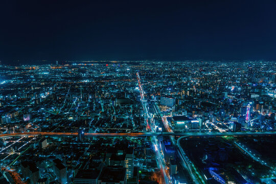
Have you ever wondered what it feels like to see the world from high above, like a bird soaring through the sky? That’s exactly what a Bird Eye View offers—a unique perspective that shows you the bigger picture.
Whether you’re planning a trip, designing a project, or just curious, understanding this view can change how you see things. Keep reading, and you’ll discover how a simple change in perspective can unlock new insights and make your decisions smarter.
Bird Eye View Basics
A bird eye view shows a scene from above. It looks like what a bird sees while flying high.
This view gives a clear picture of the whole area. People use it to understand space and layout.
Definition And Origin
A bird eye view means looking down from above. It shows objects as if from a high place.
The idea comes from maps and drawings. Artists and map makers used this view long ago.
Key Features
This view shows the layout and shape of objects clearly. It removes details that block the view.
- Shows full area from above
- Highlights shapes and paths
- Removes side views and hidden parts
- Helps in planning and design
Common Uses
Bird eye views help in many fields. They make it easy to see space and design.
- Maps to show streets and land
- Architecture to plan buildings
- Video games for player views
- Photography for wide shots

Credit: www.shutterstock.com
Types Of Bird Eye Perspectives
Bird eye view shows a scene from above. It gives a wide look at places or objects. This view helps us see things that are hard to notice from the ground.
There are different types of bird eye perspectives. Each type has its own use and style. Below, we explore some common types and what makes them unique.
High Angle View
A high angle view looks down on the subject from a steep height. It makes the subject look smaller and less powerful. Filmmakers and photographers often use this angle to show vulnerability or space.
- Often taken from tall buildings or cliffs
- Used to show large crowds or busy streets
- Creates a sense of overview and control
Aerial Photography
Aerial photography captures images from the air. Planes, helicopters, or balloons usually take these photos. This type covers large areas and shows patterns on the land.
| Method | Common Uses |
| Airplane | Mapping, city views |
| Helicopter | Events, wildlife tracking |
| Hot Air Balloon | Tourism, scenic shots |
Drone Perspectives
Drones are small flying devices with cameras. They offer flexible bird eye views. Drones can fly low or high and move easily around obstacles.
Advantages of drone perspectives include:
- Cost-effective compared to helicopters
- Can capture close-up details from above
- Used in real estate, sports, and nature filming
Benefits Of Bird Eye View
A bird eye view shows a scene from above. It gives a clear view of the whole area. This view helps in many ways.
Many fields use bird eye views to understand spaces better. It helps people plan and design well. It also looks interesting.
Enhanced Spatial Awareness
Bird eye view shows how objects relate in space. It makes it easy to see distances and positions. This helps people understand layouts fast.
It helps with navigation and finding places. People can see the big picture and details at once. This view reduces confusion in complex areas.
Improved Planning And Design
Using bird eye view helps plan spaces better. Designers can see how parts fit together from above. This view shows problems early.
It works well in city planning, building design, and landscaping. Planners can organize space to use it smartly. This saves time and money.
- Check space use clearly
- Spot design errors early
- Arrange elements with ease
- Plan routes and access points
Unique Visual Appeal
Bird eye views offer a fresh look at places. This view is less common, so it grabs attention. It makes images or videos stand out.
Artists and photographers use this view to create stunning works. It shows patterns and shapes not seen from ground level. This adds beauty and interest.
Applications In Various Fields
A bird eye view offers a high, overhead perspective. It helps see large areas at once.
This view is useful in many fields to improve planning and design. It also helps with creativity and navigation.
Urban Planning And Architecture
Urban planners use bird eye views to map cities and plan new developments. Architects see how buildings fit in the landscape.
- Analyze traffic flow and street layouts
- Plan parks, public spaces, and building locations
- Visualize the scale and relationship of structures
- Check zoning and land use efficiently
Film And Photography
Filmmakers and photographers use bird eye views for dramatic shots. This angle shows scenes from above to add interest.
Common uses include:
- Establishing shots of cities or landscapes
- Showing scale and context in scenes
- Creating unique visual effects
Gaming And Virtual Reality
Bird eye views help players see game maps and plan moves. Virtual reality uses this view for navigation and design.
| Field | Benefit | Example |
| Gaming | Better map awareness | Strategy games like chess or city builders |
| Virtual Reality | Improved scene layout | Virtual tours and training simulations |
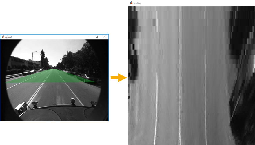
Techniques To Capture Bird Eye Views
Bird eye views show a scene from above. They help people see large areas clearly.
Many methods can capture these views. Some use technology, while others rely on manual tools.
Using Drones
Drones fly high and take pictures or videos from the sky. They are easy to control and move in many directions.
- Drones have cameras that capture clear images.
- They can reach places hard to access.
- Users can control drones remotely for precise shots.
- Battery life limits flight time, so planning is key.
Satellite Imaging
Satellites orbit Earth and take large-scale photos. They cover wide areas in one image.
| Feature | Details |
| Coverage | Very large areas |
| Resolution | Lower than drones |
| Cost | High for detailed images |
| Use | Maps, weather, and land study |
Manual Elevation Methods
Manual methods use tools like tall towers or hills to get a high view. People take photos from these points.
- Use ladders or rooftops for better height.
- Climb hills or mountains for natural elevation.
- Use balloons or kites with cameras attached.
- These methods need physical effort and good weather.
Credit: stock.adobe.com
Challenges And Limitations
Bird eye view images show scenes from above. They help in many fields like mapping and planning.
Still, this view has some challenges and limits. These can affect how well it works.
Technical Constraints
Capturing bird eye view images needs special tools like drones or satellites. These tools must fly high and stay stable.
Sometimes the weather or tall buildings block clear views. This makes it hard to get good pictures.
- Requires drones, planes, or satellites
- Weather can block or blur views
- Needs strong cameras and sensors
- Tall objects can hide areas
Cost Factors
Getting bird eye view images can be expensive. Buying and operating drones or satellites costs money.
Processing these images also needs special software and skilled workers, which add to the cost.
- High cost of drones or satellites
- Maintenance and operation fees
- Software for image processing
- Hiring trained professionals
Privacy Concerns
Bird eye view images can capture private spaces like homes and yards. This may cause privacy issues.
Rules and laws often limit where and how images can be taken. People may feel uncomfortable being watched from above.
- Captures private property without permission
- Laws restrict aerial photography
- Concerns about spying or surveillance
- Need to respect people’s privacy
Future Trends In Bird Eye Perspectives
Bird eye views show scenes from above. They help people see places clearly and easily.
New technology changes how we get and use bird eye views. This makes views better and more useful.
Advances In Drone Technology
Drones fly high and take pictures from the sky. New drones have better cameras and longer flight times.
They can fly in hard places and give clear bird eye views fast. This helps in maps, farms, and cities.
Ai And Image Processing
AI helps computers understand bird eye pictures. It finds shapes, colors, and objects in the images.
This makes bird eye views easier to use. People can get important details without looking closely at every part.
- Detects buildings and roads
- Highlights changes over time
- Improves image clarity
Interactive 3d Mapping
3D maps show places in three dimensions. Users can move around and see all sides of buildings and land.
Interactive maps let people zoom, rotate, and explore bird eye views. This helps in planning and learning.
Credit: medium.com
Frequently Asked Questions
What Does Bird Eye View Mean In Photography?
Bird eye view in photography refers to an image captured from directly above the subject. It offers a unique, top-down perspective. This angle highlights patterns, shapes, and spatial relationships often missed from ground level. It’s popular for landscapes, architecture, and creative shots.
How Is Bird Eye View Used In Maps?
Bird eye view in maps shows areas from above, simulating what a bird would see. It helps visualize locations clearly and understand layout. This view aids navigation, planning, and geographic analysis by providing an accurate overhead perspective.
Why Is Bird Eye View Important In Design?
Bird eye view helps designers see overall layout and spatial arrangement. It improves planning by revealing how elements relate. This perspective ensures balance, flow, and effective use of space, enhancing user experience and functionality in design projects.
What Industries Benefit From Bird Eye View Imagery?
Industries like real estate, urban planning, and gaming use bird eye view. It aids property showcasing, city modeling, and virtual environment creation. This perspective enhances visualization, decision-making, and immersive experiences across various fields.
Conclusion
A bird’s eye view offers a unique perspective. It reveals patterns and structures unseen from the ground. This aerial view is valuable for planning and understanding landscapes. It helps in making informed decisions. Many industries benefit from this perspective. From architecture to environmental studies, its impact is vast.
Observing from above changes how we see the world. It provides insights that ground-level views miss. Embrace this view to gain a broader understanding. This perspective can enrich your knowledge and enhance your appreciation of surroundings. Explore the world from above and discover its hidden details.


