
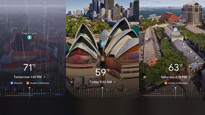
Have you ever wished you could see a location from high above, as if you were flying like a bird? Bird’s eye view maps give you that unique perspective, showing detailed images from an angled viewpoint.
But where can you find these amazing maps? If you want to explore cities, landmarks, or your own neighborhood in a whole new way, you’re in the right place. Keep reading to discover the best sites that offer bird’s eye view maps and how you can use them to satisfy your curiosity or plan your next adventure.
Your new way of seeing the world is just a click away!
Benefits Of Bird’s Eye View Maps
Bird’s eye view maps show a location from above at an angle. They give a more natural look than flat maps. Many sites offer these maps for users to explore cities and areas.
These maps help people see details and understand spaces better. They are useful for travelers, planners, and anyone curious about places.
Enhanced Navigation Experience
Bird’s eye view maps show streets and buildings in 3D-like views. This helps users find directions easier. It feels like looking around from above in real life.
Users can spot landmarks and paths quickly. This view reduces confusion compared to flat maps. It helps when walking or driving in new places.
Detailed Urban Exploration
These maps show detailed views of cities. You can see building shapes, parks, and streets clearly. It is useful for exploring areas before visiting.
People can plan visits to parks, shops, or historic sites easily. The visuals make it fun and simple to learn about new places in detail.
Improved Planning And Analysis
Bird’s eye maps help city planners and architects. They get a real view of land use and building layouts. This helps in making better decisions.
Businesses use these maps to choose good locations. They can study traffic flow and nearby facilities. This improves their planning and strategies.
Popular Platforms Featuring Bird’s Eye Maps
Bird’s eye view maps show aerial images from an angle. This view helps users see buildings and landscapes clearly.
Several popular platforms offer bird’s eye maps. These platforms provide detailed images for navigation and exploration.
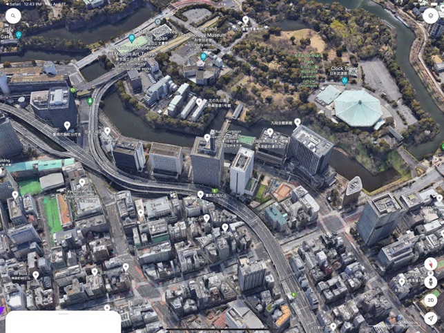
Google Earth
Google Earth offers 3D views and bird’s eye perspectives. Users can explore cities and natural sites with clear angled views.
- High-resolution aerial images
- 3D building models in many cities
- Easy zoom and rotate features
- Available on web and mobile apps
Bing Maps
Bing Maps provides a bird’s eye view that shows four directions. This gives a detailed look at streets and landmarks.
| Feature | Description |
| Bird’s Eye Angles | North, South, East, and West views |
| Image Quality | High resolution and clear details |
| Coverage | Major cities and many towns |
| Access | Web and Windows apps |
Apple Maps
Apple Maps offers flyover mode, a type of bird’s eye view. It displays cities in 3D with angled aerial images.
- Interactive 3D city models
- Flyover tours of famous locations
- Available on iPhone, iPad, and Mac
- Regular updates for image quality
Specialized Sites For Bird’s Eye Imagery
Bird’s eye view maps give a unique look at places from an angled view above. These maps help people see buildings, streets, and landscapes in detail.
Some websites specialize in showing bird’s eye imagery. They offer clear and updated views from different cities and areas worldwide.
Nearmap
Nearmap provides high-resolution bird’s eye images. It updates its photos often, giving fresh views of urban areas.
This site is useful for businesses and planners who need detailed and current maps for their projects.
Zoom Earth
Zoom Earth shows recent satellite and bird’s eye photos. It focuses on clear images from the last few days.
The site lets users explore many locations with good quality angled views. It is easy to use and free.
Here Wego
Here WeGo offers bird’s eye maps in select cities. It combines road maps with angled aerial views for better navigation.
The platform is helpful for travelers and drivers who want a clearer picture of their routes and surroundings.
Credit: www.bgr.com
Comparison Of Map Quality And Features
Bird’s eye view maps provide detailed aerial images of locations. Different websites offer these maps with various features and quality levels. Comparing them helps users choose the best option.
This article looks at image resolution, update frequency, and user tools on popular bird’s eye view map sites.
Image Resolution And Clarity
Image resolution affects how clear and detailed a bird’s eye view map appears. Some sites use high-resolution images that show buildings and streets sharply. Others may have lower resolution, making details harder to see.
- High resolution shows finer details like cars and trees.
- Clarity depends on the source of the aerial photos.
- Some sites offer zoom features to explore details closely.
- Cloud cover or shadows can affect image clarity.
Update Frequency
How often bird’s eye view maps update varies by site. Frequent updates provide recent images of construction or changes in the area. Some sites update yearly, others every few years.
| Site Name | Update Interval | Notes |
| Site A | Every 6 months | Good for fast-changing areas |
| Site B | Every 2 years | Slower updates but high image quality |
| Site C | Annually | Balances quality and frequency |
User Interface And Tools
Ease of use and tools vary among bird’s eye view map sites. Some offer simple navigation with zoom and pan. Others add features like measurement tools, 3D views, or layering options.
- Zoom controls let users see fine details.
- Measurement tools show distances and areas.
- 3D views provide perspective on building heights.
- Layer options allow toggling street names or traffic data.
Accessing Bird’s Eye Views On Mobile
Bird’s eye view maps give a detailed look at places from above. Many mobile apps now include this feature. It helps users see streets and buildings clearly on their phones.
Using bird’s eye views on mobile is easy if you know which apps to use. This guide covers app availability, how features differ, and offline options.
App Availability
Several apps show bird’s eye view maps on mobile devices. Some popular apps include mapping services and specialized bird’s eye apps.
- Google Maps offers bird’s eye views in some cities via satellite imagery.
- Bing Maps provides clear bird’s eye views in many urban areas.
- Apple Maps includes 3D and bird’s eye perspectives on iOS devices.
- Specialized apps like NearMap focus on high-resolution aerial images.
Functionality Differences
Bird’s eye view features vary by app. Some apps show only static images. Others allow zooming, rotating, and switching angles.
| App | Zoom Levels | Rotation | 3D View |
| Google Maps | Yes | Yes | Limited |
| Bing Maps | Yes | No | No |
| Apple Maps | Yes | Yes | Yes |
| NearMap | High | Yes | No |
Offline Usage Options
Using bird’s eye views offline is limited but possible. Some apps let you save map areas to your phone before going offline.
- Google Maps lets you download areas including satellite views for offline use.
- Apple Maps caches some map data but has limited offline bird’s eye options.
- Specialized apps may offer downloadable images or offline packages.
Credit: apps.apple.com
Applications Of Bird’s Eye Maps
Bird’s eye view maps show an angled view from above. They give a clear picture of areas and buildings. These maps help people see details hard to find on flat maps.
Many industries use bird’s eye maps for better planning and decisions. They help in real estate, travel, and emergency services.
Real Estate And Property Analysis
Bird’s eye maps help buyers and sellers see property layouts. They show house positions, yards, and neighborhood views. This helps in choosing the best property.
Real estate agents use these maps to explain property features. They also check nearby facilities like schools and parks. This makes property analysis easier and clearer.
Travel And Tourism
Tourists use bird’s eye maps to explore cities and landmarks. These maps show popular spots and walking paths. Travelers can plan trips better with this view.
Tour guides and travel companies use bird’s eye maps to design tours. They highlight attractions and routes. This helps visitors find places quickly and enjoy their visit.
Emergency Response Planning
Emergency teams use bird’s eye maps to plan rescue operations. They see buildings, roads, and obstacles from above. This helps in quick and safe responses.
These maps help in disaster management and evacuation planning. Officials can spot safe zones and risky areas. This improves public safety during emergencies.
Future Trends In Bird’s Eye Mapping
Bird’s eye view maps show places from above at an angle. They help people see buildings and streets clearly. New technology is changing how these maps are made and used.
These maps will get better with new tools. They will become more interactive and detailed. Let’s look at some future trends in bird’s eye mapping.
Integration With Ar And Vr
Augmented reality (AR) and virtual reality (VR) add digital layers to real views. Bird’s eye maps can be used with AR and VR to create immersive experiences. People can explore cities or buildings from the sky using these tools.
This integration helps in planning, education, and tourism. Users can walk through a virtual city or see changes before they happen. It makes maps more useful and fun to explore.
Ai-enhanced Imagery
Artificial intelligence (AI) helps improve the quality of bird’s eye maps. AI can remove blurs and fill missing parts in images. It also helps create 3D models from 2D photos quickly.
AI speeds up map updates and makes images clearer. This leads to more accurate and detailed views for users. It also lowers the cost of making bird’s eye maps.
Crowdsourced Updates
Crowdsourcing means many people help collect information. Users can send photos or report changes in their area. This helps keep bird’s eye maps current and correct.
Maps with crowdsourced data update faster than traditional ones. They show new buildings, roads, and landmarks quickly. This trend makes maps more reliable for everyday use.

Credit: en.wikipedia.org
Frequently Asked Questions
What Sites Offer A Bird’s Eye View Maps?
Google Maps and Bing Maps provide bird’s eye view maps. These platforms offer detailed aerial imagery. Users can explore cities and landscapes from above. This feature enhances navigation and planning. Both services are accessible on mobile and desktop.
How Can I Access Bird’s Eye View On Google Maps?
To access bird’s eye view, open Google Maps. Enter a location and switch to satellite view. Zoom in for detailed aerial imagery. This view offers a unique perspective. It’s perfect for exploring unfamiliar areas.
Does Bing Maps Have A Bird’s Eye View Feature?
Yes, Bing Maps offers a bird’s eye view feature. It provides high-resolution aerial images. Users can explore cities and terrains in detail. This feature is accessible through the map’s settings. It’s a great tool for urban and rural exploration.
Are Bird’s Eye View Maps Free To Use?
Yes, bird’s eye view maps on Google and Bing are free. Both platforms offer this feature without charge. Users can explore without any subscription. It’s a valuable resource for travelers and planners alike. Enjoy detailed aerial perspectives at no cost.
Conclusion
Bird’s eye view maps offer a unique way to see the world. Many websites provide these detailed, angled images. They help with navigation, planning, and exploring new places. Some sites focus on cities, while others cover rural areas. Choosing the right site depends on your needs.
Now, you know where to find bird’s eye maps easily. Start exploring from above and enjoy a fresh perspective.


