
Have you ever wanted to see your neighborhood, a famous landmark, or a faraway city from high above? Seeing a bird’s eye view on Google Earth can give you that amazing perspective.
It’s like flying without leaving your home. In this guide, you’ll learn exactly how to get that stunning top-down view quickly and easily. Whether you’re planning a trip, exploring new places, or just curious, this simple trick will change how you see the world.
Keep reading to discover how to unlock this powerful feature and amaze yourself with the views you can find.

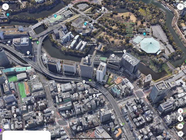
Credit: www.reddit.com
Accessing Google Earth
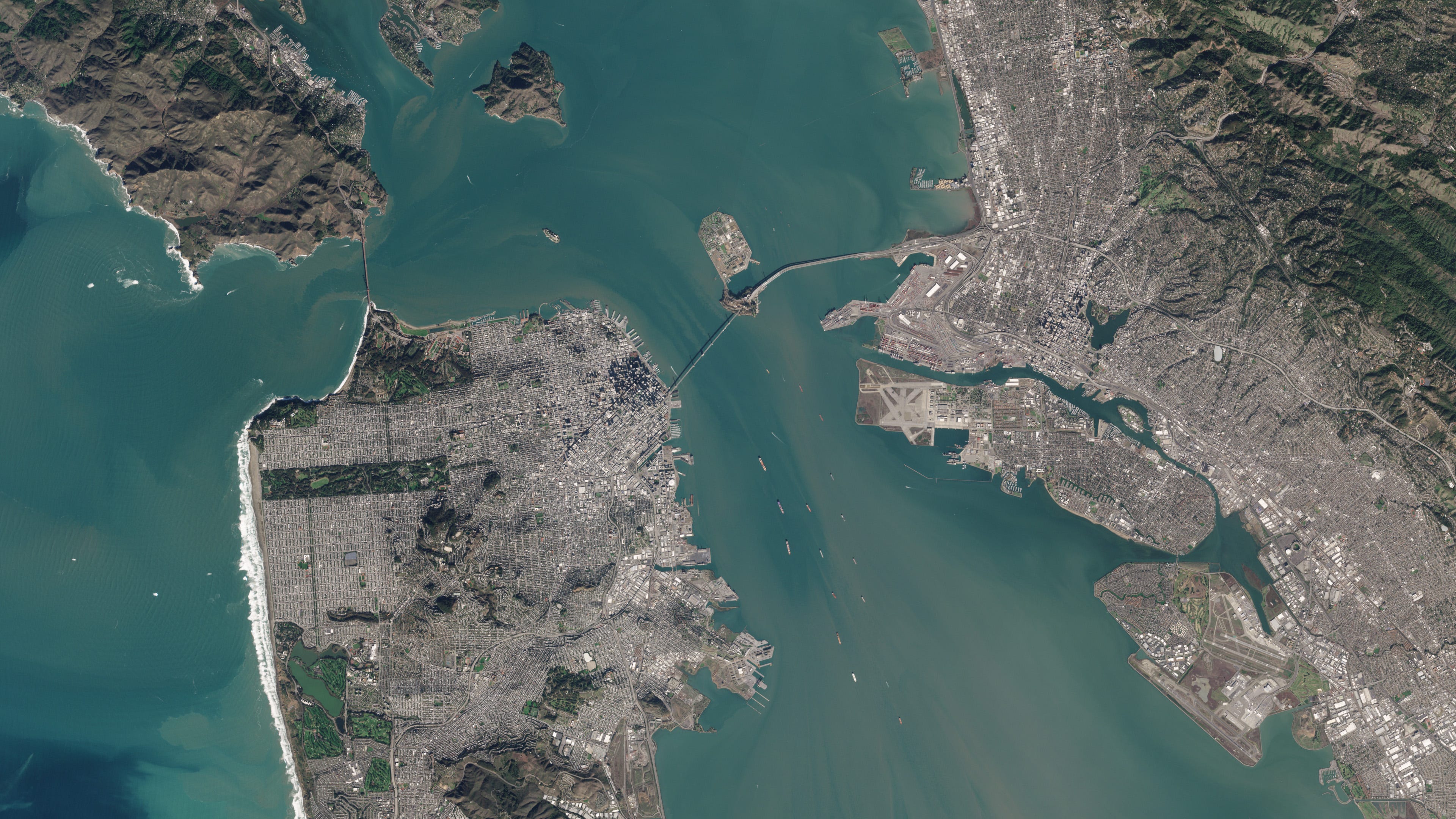
Google Earth lets you explore the world from above. You can see cities, mountains, and oceans. It also offers a bird’s eye view for detailed imagery.
There are several ways to access Google Earth. You can use a web browser, download a desktop app, or use a mobile app. Each method has its own features.
Using The Web Version
Open your web browser and go to the Google Earth website. This version does not need any download. You can start exploring right away.
- Visit earth.google.com
- Click “Launch Earth” to open the viewer
- Use the mouse or touchpad to zoom and move
- Click on the “Voyager” icon for guided tours
Downloading The Desktop App
The desktop app offers more tools and smoother navigation. You need to download and install it on your computer. It works on Windows, Mac, and Linux.
| Step | Action |
| 1 | Go to the Google Earth download page |
| 2 | Select your operating system |
| 3 | Download and run the installer |
| 4 | Open the app and sign in if needed |
Mobile App Options
You can also use Google Earth on your phone or tablet. The app works on both Android and iOS devices. It lets you explore places using touch gestures.
- Download Google Earth from Google Play or App Store
- Open the app and search for places
- Use pinch gestures to zoom in and out
- Tap the compass to change the view angle
Navigating To Your Location
Google Earth lets you see places from a bird’s eye view. You can easily find your location and explore the area.
This guide shows how to navigate to your location using different tools in Google Earth.
Search Bar Tips
The search bar is the fastest way to find places on Google Earth. Type the name of a city, address, or landmark.
Use simple words and avoid extra details for better results. Press Enter to jump to the location.
- Type city or town names
- Enter full addresses for exact spots
- Use landmarks like “Eiffel Tower”
- Check spelling to avoid errors
Using Coordinates
You can also enter latitude and longitude coordinates in the search bar. This gives you precise locations.
Coordinates use numbers and symbols like degrees (°), minutes (‘), and seconds (“). You can find these online or from GPS devices.
- Use decimal format: 40.7128, -74.0060
- Or degrees format: 40°42’51″N 74°0’21″W
- Separate latitude and longitude with a comma
- Copy and paste for accuracy
Exploring Popular Spots
Google Earth has many famous places ready to explore. You can browse popular spots and see them from above.
Click on these spots to zoom in and get a bird’s eye view. This helps if you want to visit or learn about new places.
- Famous cities like New York or Paris
- Natural wonders like the Grand Canyon
- Historic sites like the Great Wall of China
- Tourist attractions and parks
Activating Bird’s Eye View
Bird’s Eye View on Google Earth gives a detailed look at locations from an angled perspective. It shows buildings and landscapes in 3D, making it easy to understand the area.
This guide explains how to activate Bird’s Eye View by switching to 3D mode, adjusting the viewing angle, and using tilt controls.
Switching To 3d Mode
To see Bird’s Eye View, start by switching Google Earth from 2D to 3D mode. This mode displays buildings and terrain in three dimensions.
- Open Google Earth on your device.
- Look for the 3D button on the screen, usually at the bottom right corner.
- Click or tap the 3D button to activate 3D mode.
- Wait a moment for the map to switch and load 3D imagery.
Adjusting The Viewing Angle
After switching to 3D mode, adjust the viewing angle to get the best Bird’s Eye View. This helps you see buildings and landscapes clearly.
| Action | Effect |
| Drag the mouse up or down | Changes the tilt of the view |
| Scroll the mouse wheel | Zooms in or out |
| Use two fingers on touchpad | Rotate or tilt the map |
Using Tilt Controls
Tilt controls help you change the angle of view smoothly. Use these controls to see the area from different heights and angles.
Common ways to use tilt controls:
- Press and hold the tilt button on the screen.
- Drag up or down to tilt the view.
- Use keyboard shortcuts like Shift + Up/Down arrow keys.
Credit: apps.apple.com
Enhancing Your Experience
Google Earth offers a unique way to see the world from above. You can explore different places with a bird’s eye view. Learning some tips will make your experience better and easier.
This guide explains how to zoom, use layers, and add street views. These features help you see more details and enjoy your virtual travels.
Zooming Techniques
Zooming in and out changes how close you are to the ground. You can see large areas or small details. Use the mouse wheel or the zoom buttons on the screen. Double-clicking also zooms in quickly.
- Scroll mouse wheel forward to zoom in
- Scroll mouse wheel backward to zoom out
- Click plus (+) and minus (–) buttons for precise control
- Double-click on a spot to zoom in fast
- Use keyboard shortcuts like + and – keys
Layer Options
Layers add extra information to the map. You can see roads, borders, places, and more. Turning layers on or off helps focus on what you want to see.
| Layer | Description | Use Case |
| Roads | Shows streets and highways | Find routes and directions |
| 3D Buildings | Displays three-dimensional buildings | Explore city shapes and sizes |
| Borders and Labels | Shows country and state lines | Understand political boundaries |
| Photos | Displays user photos of places | See real pictures from locations |
Street View Integration
Street View lets you see places as if you are there on the ground. You can walk around and look in all directions. It adds a real-life feel to your bird’s eye view.
To use Street View:
- Drag the orange Pegman icon onto the map.
- Drop it on blue-highlighted streets.
- Use arrows to move along the street.
- Click and drag to look around 360 degrees.
Troubleshooting Common Issues
Seeing a birds eye view on Google Earth can sometimes cause problems. These issues might stop the view from loading or make images unclear. This guide helps you fix common problems easily.
Follow simple steps to improve your experience with Google Earth’s birds eye view. Fix loading issues, enhance picture quality, and handle missing data without stress.
Fixing Loading Problems
Sometimes Google Earth takes too long to show the birds eye view. This can happen due to slow internet or app errors. Restarting the app or checking your connection often helps.
Clearing the app cache can also fix loading problems. Make sure your device meets the app’s requirements and update Google Earth to the latest version.
- Check your internet speed and connection
- Restart Google Earth or your device
- Clear app cache from settings
- Update Google Earth to the newest version
- Close other apps to free memory
Improving Image Quality
Birds eye images may look blurry or pixelated. This happens if the image resolution is low or the zoom level is too high. Adjusting the zoom can improve clarity.
Switching to a higher quality setting in Google Earth helps. Also, clear your browser cache if you use the web version.
- Zoom out slightly for clearer images
- Set image quality to high in settings
- Clear browser or app cache
- Use a device with better screen resolution
Dealing With Missing Data
Some places may not show birds eye views because data is missing. This can be due to privacy rules or lack of recent images. Try searching nearby areas for better views.
Report missing images to Google Earth. They update maps regularly, so data may appear later.
- Search different nearby locations
- Check back later for updates
- Send feedback to Google Earth about missing images
- Use satellite view as an alternative
Advanced Tips And Tricks
Google Earth offers more than just a basic bird’s eye view. You can explore detailed maps and create your own views. These tips help you use Google Earth like a pro.
Learn how to save views, use historical images, and make tours. These tools make your experience richer and more useful.
Saving Custom Views
You can save your favorite bird’s eye views in Google Earth. This helps you return to exact spots quickly. It is useful for projects or repeated visits.
To save a view, adjust the angle and zoom until you like it. Then click the “Add Placemark” button. Name your view and save it.
- Zoom and tilt the map to your preferred view
- Click “Add Placemark” to save the location
- Name the view for easy reference
- Access saved views from the “My Places” panel
Using Historical Imagery
Google Earth lets you see past images of many locations. This shows how places change over time. It is helpful for study and comparison.
Click the clock icon on the toolbar to open the historical imagery. Use the slider to choose a year. The map updates to show the past view.
- Click the clock icon to open time slider
- Drag the slider to pick a past date
- Observe changes in landscapes or buildings
- Use this for research or personal interest
Creating Tours
Tours let you record a path through Google Earth. You can add narration and save the tour. This is great for sharing your bird’s eye views.
Start by clicking the “Record Tour” button. Fly to places you want to include. Speak or add notes while recording. Save and play your tour anytime.
- Click “Record Tour” to begin
- Navigate through your selected views
- Add voice or text comments during recording
- Save the tour for future use or sharing
Credit: medium.com
Frequently Asked Questions
How Do I Enable Bird’s Eye View On Google Earth?
To enable Bird’s Eye View on Google Earth, zoom in close to your location. Use the tilt and rotate tools to adjust the angle. This view offers a 3D-like perspective for better detail and landscape visualization.
Can I See Bird’s Eye View On Google Earth For Any Location?
Bird’s Eye View is available for many urban and popular areas on Google Earth. However, it may not be accessible for all remote or rural locations due to limited imagery data.
What Devices Support Bird’s Eye View On Google Earth?
Bird’s Eye View on Google Earth is supported on desktop browsers and mobile apps. Make sure your device and app version are updated for the best experience.
How Is Bird’s Eye View Different From Satellite View?
Bird’s Eye View shows angled, 3D-like images, while Satellite View offers a straight-down, 2D perspective. Bird’s Eye provides more depth and detail of buildings and terrain.
Conclusion
Exploring Google Earth’s bird’s eye view is simple and fun. You can see places from above, offering a unique perspective. Use this tool for planning trips or just exploring the world. Remember, zoom in and out for better details. Practice often to become more familiar with the features.
It’s a great way to learn about different places. Enjoy discovering new sights and landscapes. Keep exploring, and let your curiosity lead the way. Google Earth makes it easy to see the world like never before. Dive into these views and enjoy your virtual travels.


